
























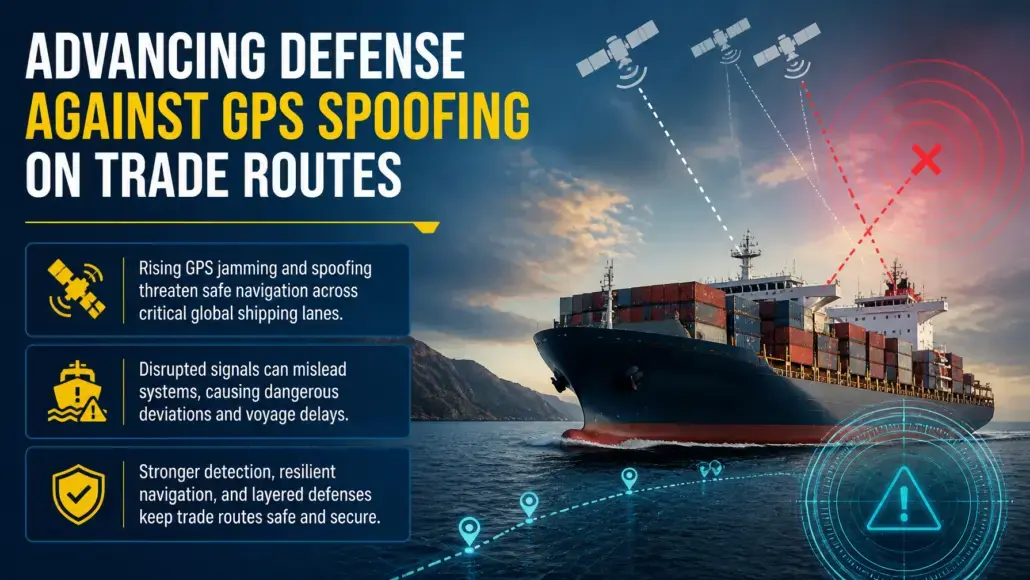
Electronic warfare techniques once confined to specialized military theaters have spilled directly into commercial shipping lanes, exposing merchant vessels to dangerous navigational disorientation. Across vital maritime chokepoints, including the Baltic Sea, the Red Sea, the Strait of Hormuz, and the Black Sea, commercial ships are experiencing unprecedented levels of global navigation satellite system interference. Intentional signal jamming overwhelms bridge receivers, while sophisticated electronic spoofing broadcasts false coordinates that fool onboard instruments into showing false positions miles away from actual locations.
Transport Advancement notes that these electronic disruptions create severe physical risks for international commerce. Modern merchant vessels rely on satellite coordinates to steer automated autopilots, calibrate radar overlays, stabilize dynamic positioning systems, and transmit accurate automatic identification system broadcasts. When electronic spoofing falsifies position data, vessels risk grounding on shallow shoals, veering into restricted military zones, or colliding in dense traffic separation schemes. Consequently, maritime GPS spoofing defense has evolved from an obscure technical contingency into an urgent operational priority for international shipping lines, maritime insurers, and port authorities.
Mechanics of Satellite Interference in Commercial Sea Lanes
Understanding the vulnerability of commercial navigation begins with the fundamental physics of global navigation satellite systems. Satellites orbiting approximately twenty thousand kilometers above the Earth broadcast timing and positioning signals that arrive at sea-level antenna domes at exceptionally low power levels. Terrestrial electronic warfare transmitters, operating with high-wattage amplifiers, easily drown out these fragile satellite signals across vast coastal expanses.
Electronic interference manifests primarily in two distinct forms across merchant sea lanes:
- Direct radio frequency jamming floods the designated satellite spectrum with broadband noise, preventing bridge receivers from locking onto satellite timing signals and triggering sudden loss of signal alarms.
- Coordinated electronic spoofing transmits forged radio signals that mimic authentic satellite constellations, gradually altering timing pulses to manipulate calculated vessel coordinates, heading, and speed without triggering automated bridge alarms.
GPS Spoofing attacks are uniquely treacherous because they manipulate dependent electronic systems across the entire bridge console. An electronic chart display and information system fed by a spoofed receiver displays the vessel sailing safely within a dredged channel, while the physical hull is drifting toward shallow rocks. Simultaneously, automatic identification system transponders broadcast the false position to neighboring traffic and coastal vessel traffic services, sowing widespread confusion across busy harbor approaches.
In several documented incidents across contested straits, GPS spoofing attacks manipulated vessel clock offsets by microseconds. Because satellite navigation relies on exact time-of-flight measurements, altering internal clock signals creates phantom vessel movements that cause bridge track-control autopilots to make sudden, uncommanded rudder turns. If an uncommanded turn occurs while navigating a narrow dredged canal, the vessel risks catastrophic bank suction or grounding before watchstanders can disengage automated steering.
Economic and Geopolitical Repercussions for Global Shipping
The proliferation of electronic navigation warfare directly undermines maritime commercial predictability. In high-density shipping corridors, false position data forces master mariners to disengage automated track-control autopilots and revert to manual steering. This sudden loss of automated precision increases crew fatigue, forces vessels to drop speed, and compounds transit delays across tightly scheduled container networks.
Marine insurance underwriters have responded by re-evaluating risk exposure along contested international sea lanes. Under standard Institute Cyber Attack Clauses, underwriters historically excluded losses caused by malicious electronic interference. As state-sponsored electronic warfare becomes a routine hazard of merchant trade, shipowners must prove robust bridge cyber resilience and verified secondary navigation procedures to maintain comprehensive hull and machinery coverage.

Regulatory frameworks have simultaneously hardened. In 2024 and 2025, the International Association of Classification Societies enacted Unified Requirements E26 and E27, mandating cyber resilience for onboard operational technology on all newly constructed commercial vessels. Under these binding rules, classification societies certify that shipboard navigation and propulsion controls possess integrated defenses against unauthorized digital manipulation, network intrusion, and corrupted sensor feeds.
Port state control authorities are also taking aggressive enforcement action. Vessels arriving at major international transshipment ports with malfunctioning automatic identification systems or unresolved bridge navigation alarms face mandatory physical safety inspections and potential commercial detention until technicians verify sensor calibration.
Multi-Layered Navigational Defenses and Terrestrial Backups
Defeating electronic positioning attacks requires a defense-in-depth architecture that blends space-based, terrestrial, and shipboard autonomous sensors. Modern bridge consoles increasingly deploy sensor fusion engines that treat satellite positioning merely as one input among many, rather than an unquestioned source of navigational truth. By integrating marine radar overlays, echo sounders, and Doppler velocity logs, bridge systems calculate independent dead reckoning vectors that instantly expose artificial satellite position jumps.
Inertial navigation systems, historically restricted to naval submarines due to cost, are becoming standard auxiliary equipment on deep-sea commercial vessels. High-precision fiber optic gyroscopes and ring laser gyroscopes measure angular velocity and linear acceleration without reference to external radio transmissions. Once initialized, an inertial navigation unit calculates precise vessel movement entirely from internal sensors, remaining completely immune to radio frequency jamming, coastal spoofing, and orbital satellite disruptions.
On regional scales, coastal nations are revitalizing enhanced terrestrial radio navigation networks, commonly known as eLoran. Unlike satellite signals, low-frequency eLoran transmitters broadcast multi-megawatt pulses that penetrate atmospheric interference and cannot be jammed by conventional tactical electronic warfare transmitters. Vessels equipped with integrated eLoran receivers obtain resilient position and precise timing data even when satellite frequencies across entire maritime basins are completely denied.
Protecting vessels from digital spoofing during coastal transit is only half the battle, because harbor facilities themselves require continuous physical integrity checks, as highlighted in Underwater Drone Inspections Maintaining Port Infrastructure without Divers.
Crew Training and Operational Bridge Discipline
Technological hardware remains ineffective without rigorous operational bridge discipline. Modern deck officers must be trained to recognize the subtle psychological and mechanical indicators of electronic spoofing. A sudden jump in satellite clock timing, unexpected discrepancies between radar coastlines and electronic chart vectors, or erratic automatic identification system tracks on adjacent vessels must immediately trigger manual navigation procedures.
Leading maritime academies and shipping lines are revising bridge resource management curricula to re-emphasize traditional navigational fundamentals. Deck officers spend mandatory training hours practicing optical bearing fixes, visual range markers, radar parallel indexing, and celestial navigation. By maintaining sharp manual plotting skills alongside automated sensors, commercial mariners ensure that electronic warfare cannot paralyze bridge command.
Transport Advancement observes that the commercial maritime domain has entered an era where electronic space is as contested as physical waters. Shipping operators who invest in hardened antenna arrays, inertial navigation backups, and rigorous officer training are safeguarding their physical assets, protecting crew safety, and maintaining the unbroken flow of international trade across contested sea corridors.
