




















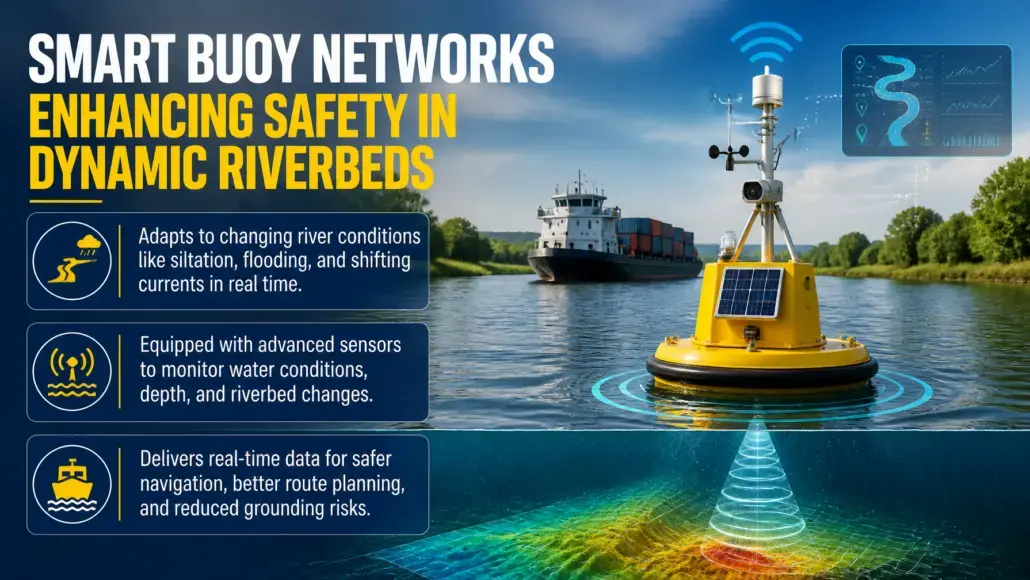
Navigating inland waterways has historically been a challenge due to the unpredictable and dynamic nature of riverbeds. Siltation, seasonal flooding, and changing currents can alter the depth and location of a safe navigation channel in a matter of days. In 2026, the maritime industry is addressing this issue through the deployment of smart buoy networks. These advanced navigation aids are equipped with a variety of sensors that provide real time data on water conditions, bathymetry, and vessel movements, transforming river safety from a reactive to a proactive discipline.
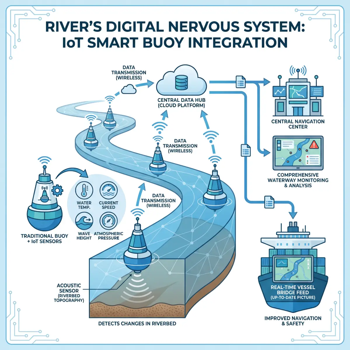
The integration of IoT technology into traditional buoys has created a comprehensive monitoring system that functions as a digital nervous system for the river. These smart buoys are capable of measuring water temperature, current speed, wave height, and atmospheric pressure. Most importantly, many are now equipped with acoustic sensors that can detect changes in the riverbed topography. This data is transmitted to central navigation centers and directly to vessel bridges, providing an up to date picture of the waterway that was previously impossible to maintain.
Real Time Digital Charts and Hydrological Monitoring
Transport Advancement observes that the primary benefit of smart buoy networks is the creation of real time digital charts. In the past, river pilots relied on physical markers and periodic surveys that could quickly become outdated. Today, the data from smart buoys is used to update electronic navigation charts (ENCs) automatically. This ensures that vessel operators are always working with the most accurate information available, significantly reducing the risk of grounding in shifting channels.
Fugro and Xylem have been pioneers in developing the sensor arrays used in these networks. Their systems utilize high precision GNSS and acoustic Doppler current profilers (ADCPs) to provide a granular view of the hydraulic environment. This information is critical for the safe passage of deep draught vessels, particularly in narrow river sections where the margin for error is minimal. The ability to monitor water levels in real time also allows port authorities to optimize the loading of barges, ensuring that they can maximize their cargo capacity without compromising safety.
Enhancing Safety for Autonomous and Large Vessels
The rise of autonomous barge navigation and the increasing size of inland freight vessels have further underscored the need for reliable navigation aids. Autonomous systems require high fidelity data to make real time decisions about route planning and collision avoidance. Smart buoy networks provide the environmental context that these systems need to operate safely in complex river environments. By providing a constant stream of data on currents and channel boundaries, these buoys act as a critical external sensor for autonomous vessels.
For larger traditional vessels, the benefits are equally significant. The ability to receive real time alerts about sudden changes in channel depth or the presence of obstacles allows captains to take corrective action before a dangerous situation develops. This is particularly important in regions prone to extreme weather events, where river conditions can change rapidly. The increased reliability of the waterway network also makes waterborne transport a more attractive option for shippers, supporting the broader trend of intermodal supply chain diversification to reduce the reliance on road freight.
Leading Companies and Technology Innovations
The development and deployment of smart buoy networks are being driven by a group of global technology leaders and specialized maritime engineering firms.
- Fugro: Fugro has deployed its Seawatch smart buoy systems in various river and coastal environments. These buoys provide a wide range of meteorological and oceanographic data, which is integrated into their SeaView navigation platform. In 2025, Fugro launched a new generation of buoys specifically designed for the high turbidity environments found in many inland rivers.
- Trelleborg Marine & Infrastructure: Trelleborg provides the docking and mooring systems that are increasingly integrated with smart buoy data. Their SafePilot solution uses real time environmental data to assist pilots during the most critical phases of a voyage. In 2026, they introduced a modular buoy design that can be easily customized with different sensor packages.
- Xylem (YSI): Through its YSI brand, Xylem provides the water quality and hydrological sensors that are the core of many smart buoy networks. Their sensors are known for their durability and accuracy in challenging underwater conditions. Their recent developments focus on low power, high frequency data transmission for remote locations.
- Sonardyne: This UK based company specializes in underwater acoustic positioning and communication. Their technology is used to monitor the stability of the riverbed and the position of underwater infrastructure. In 2026, they collaborated with several port authorities to create integrated smart channel networks that combine surface buoys with subsea sensors.
- Kongsberg Maritime: Kongsberg integrates smart buoy data into its broader suite of maritime big data analytics. Their platforms provide a holistic view of the waterway, allowing for better traffic management and more efficient port operations. Their experience in autonomous shipping ensures that buoy data is optimized for use by automated navigation systems.
Future Infrastructure and Data Integration
As more buoys are connected to the network, the volume of data available for analysis will increase significantly. This will allow for the development of predictive models that can forecast changes in the riverbed before they occur. AI driven analysis of historical hydrological data can identify patterns of siltation, helping port authorities to plan dredging operations more effectively. This transition from monitoring to prediction is the next frontier for smart waterway management.
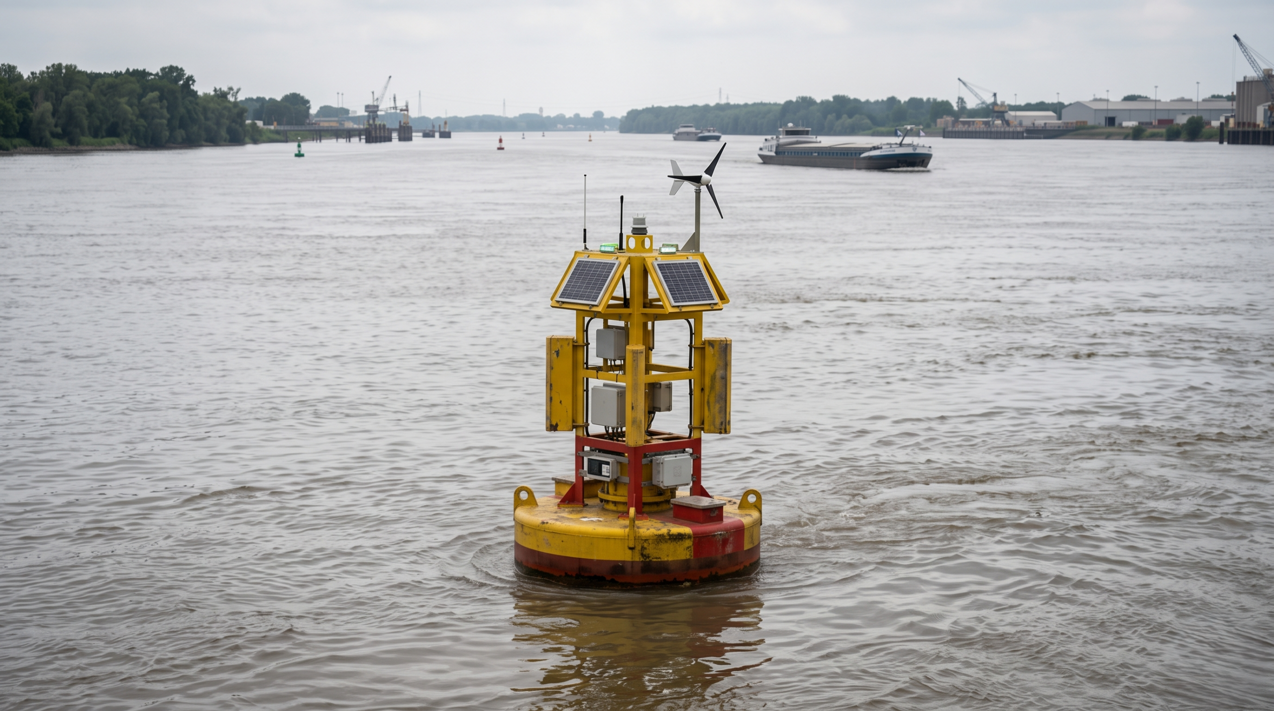
The future of navigational safety in dynamic riverbeds depends on the continued integration of these disparate data sources. By combining satellite imagery, aerial drone surveys, and smart buoy data, the industry can create a truly comprehensive digital twin of the inland waterway network. In 2026, many major river systems have implemented a unified data platform that allows all stakeholders to access this digital twin in real time. This level of transparency will ensure that river transport remains a safe, reliable, and efficient component of the global supply chain for years to come. Additionally, the use of subsea acoustic modems has enabled the integration of deep water sensors with surface buoys, providing a three dimensional view of the aquatic environment that was previously unavailable.
Predictive Maintenance and Lifespan of Smart Infrastructure
The harsh underwater environment poses significant challenges for the durability and maintenance of smart buoy networks. Biofouling, corrosion, and physical damage from floating debris or vessel collisions can all degrade the performance of the sensors. In 2026, the industry has turned to predictive maintenance to address these issues. By analyzing the performance data of each buoy, operators can identify early signs of sensor degradation and schedule maintenance before a failure occurs. This reduces the number of emergency repair visits and ensures that the network remains fully operational at all times.
The development of self cleaning sensors and advanced anti fouling coatings has also extended the service life of these devices. Many modern smart buoys are designed with a modular sensor housing that can be easily accessed and serviced without removing the entire buoy from the water. Furthermore, the use of renewable energy sources, such as solar panels and small wind turbines, has made these buoys more self sufficient, allowing them to operate in remote locations for extended periods with minimal intervention. This focus on reliability and sustainability is essential for the long term viability of smart waterway infrastructure.
Collaborative Data Ecosystems and Governance
The management of smart buoy networks involves a complex ecosystem of data providers, government agencies, and commercial users. In 2026, the industry has seen the emergence of data sharing cooperatives where the costs and benefits of the network are shared among all stakeholders. This collaborative approach ensures that the data is collected and managed in a way that serves the interests of the entire maritime community, rather than just a single organization.
The governance of these networks is also a critical consideration. Standardized data formats and communication protocols are essential for ensuring that the information from different networks can be integrated into a single global navigation system. The International Hydrographic Organization (IHO) and the International Association of Marine Aids to Navigation and Lighthouse Authorities (IALA) are playing a leading role in the development of these standards. Transport Advancement believes that by working together to establish common rules for data quality and security, the industry can ensure that smart buoy networks continue to provide a safe and reliable foundation for the next generation of inland and coastal navigation.
References
- “Monitoring Buoy Market Size, Share and Growth Report 2026” – Datahorizzon Research
- “Smart buoy to improve navigation safety” – SomInnPort
- “Top 25 Companies in Global Marine Big Data Market” – Spherical Insights
- “Xylem Hydrological Monitoring Solutions Annual Review 2025” – Xylem
- “Fugro SeaView Navigation Platform Technical Specifications” – Fugro
- “Predictive Maintenance Strategies for Maritime Infrastructure” – Trelleborg Marine Review
- “IHO Standards for Digital Hydrographic Data 2025” – International Hydrographic Organization
